Jeju Island is often called “the museum of volcanic creations” as it was created by immense volcanic activities. The Postech Times visited Jeju Island to cover its geological features.
Formation of Udo Island and its Coasts
On the eastern sea of Jeju, there is Udo Island, which was formed 70,000 years ago by volcanic activity. Udo Island has a steep terrain on the southern side of the island and a gradual terrain on the northern side due to the volcanic eruption pattern. In the early stages of its formation, seawater and magma met and exploded violently, forming a relatively high and sloping hydro volcano called tuff. The southern terrain was formed by these tuffs while the lava that erupted afterwards formed the northern gradual terrain of Udo Island.
Udo Island has two significant coasts, Sanho Beach and Geommeolle Beach. Sanho Beach was designated as national natural monument No.438 in 2004. Sanho Beach is located on the western side of Udo Island formed by the red algal nodules, which is made by red algae precipitating calcium carbonate. On Udo Island, these red algal nodules were carried to the coast by repeated typhoons. Actually, the particles on Sanho Beach are not just rocks and sand but small fragments of white corals. Unlike Sanho Beach, Geommelloe Beach has black sand. The waves caused the erosion of black volcanic rocks near the coast, which accumulated on Geommelloe Beach. Tourists visiting Udo Island can see the contrast between the two coasts.
Manjanggul Lava Tube
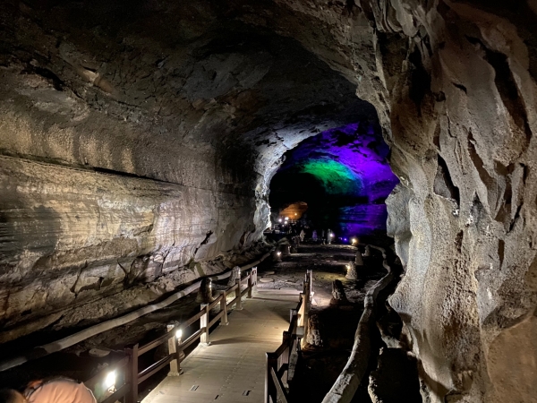
The Geomunoreum lava tube system of Jeju was listed as a UNESCO’s World Heritage site in 2007. The system is a group of lava tubes that was made about 8,000 years ago. The system starts from the Geomunoreum volcano and extends 13 kilometers linearly out to sea. It is divided into the Bengwigul Lava Tube, Utsanjeongul Lava Tube, Daerimgul Lava Tube, Manjanggul Lava Tube, Gimnyeoggul Lava Tube, Yongcheondonggul Lava Tube, and the Dangcheomuldonggul Lava Tube.
The only lava tube in the Geomunoreum system that is currently open to the public is the Manjanggul Lava Tube, the longest at 7.4 kilometer. Its interior shape is very well-preserved and hence has great scientific and geological value. It is the first cave to be designated as a natural monument (No. 98, 1962) in Korea and became part of the Global Geopark in 2010.
The lava tubes of Jeju Island were known to residents for a long time. Tamna Sullyeokdo, a book of paintings written in 1702 (the 28th year of King Sukjong’s Reign), provides visual and written records of the governor making an official inspection of the Gimnyeoggul Lava Tube. However, the Manjanggul Lava Tube was first discovered in 1946 by the teacher Bu Jong-hue and 30 of his students at Gimnyeong Elementary school. They went out spelunking with just a few torches, and the cave became known to the world through their remarkable effort.
The lava tube is divided into two sections. Only the first section (about one kilometer) is open to the public. The Postech Times explored the public section where many lava features were visible such as lava flow lines, lava stalactites, rock falls, lava rafts, Quartzite fragments, lava shelves, and lava flowstones. In particular, the 7.6 meter lava column at the end of the open section is known to be the largest lava column in the world. Lava columns are formed when lava pours down from the ceiling to the floor and congeals. Lava poured from the ceiling to the floor of the lower passage and made lava toes, a series of elongated and entangled lobes. Another notable lava product was Turtle Rock, a lava raft shaped like Jeju Island and a symbol of the Manjanggul Lava Tube. It was formed after a fallen rock settled on the floor, and hot lava accreted around its margin.
Evidence of Volcanic Activity, Seopjikoji
The Postech Times visited Seopjikoji, which is located on the eastern side of Jeju. “Seopji” means a narrow piece of land, and “koji”, a dialect of Jeju Island, means “cape”. Seopjikoji is a great place to learn about volcanic activities. Seopjikoji itself is an enormous sediment of scoria, a rock that is formed when magma containing abundant dissolved gas flows from a volcano or is blown out during an eruption. There is a remarkable rock on the east end of Seopjikoji, Seondolbawi. Seondolbawi is a volcanic neck, which was formed when magma passing through the vent cooled down. Right next to Seondolbawi, there is the Bulgeunoreum, which is a small extinct volcano. By investigating the beddings of Bulgeunoreum and Seondolbawi, geologists explain that Seondolbawi is the central part of the volcanic vent of Bulgeunoreum. Seondolbawi is the only discovered vent of an Oreum (small extinct volcano), out of the 360 Oreums of Jeju Island, and therefore, has geological value.